
Fully a week after Category 5 typhoon Odette (“Rai”) struck key regions of the Visayas and Mindanao, still nobody in government nor in the private sector knows exactly, just how the super howler developed, the extent of its damage, and the number of its victims.
Except that the typhoon began as a Category 1 as it entered the Philippines on Thursday, Dec. 16, 2021 and within 24 hours became a Category 5 super typhoon with winds of 270 kph. It then killed more than 375, with scores missing and presumed dead. More than 500 were injured.
About 110 died in charming Bohol island. Bohol Governor Arthur Yap told CNN Philippines the death toll could rise as a lack of mobile telephone links made it hard to gather information. In nearly every devastated area, there is a severe shortage of food, water, medicines, fuel, power, construction materials, and cellphone signal. Bohol Governor Yap asked the Manila government if it could not send food immediately, it send troops to contain the crowd that would loot stores and warehouses.
Odette wrought havoc in its 400-km trail, from Surigao provinces and surfing spots tear-drop shaped Siargao and Dinagat islands in northeast Mindanao, up to Cebu, and Leyte in central and eastern Philippines. Then it veered left towards Palawan to exit.
Easily half of Mindanao and most of central Philippines in the Visayas were devastated, totally in many areas.

Mindanao contributes 13% of the national output or GDP (gross domestic product) while the central Visayas with Cebu as its hub accounts for another 10%. So half of Mindanao GDP, or 6.5% plus 10% translates into a 16.5% share of economic output. Based on an annual GDP of P17 trillion, 16.5% would be equivalent to an annual output of P2.805 trillion.
Because Odette’s impact could last for a month, 1/12th of P2.805 trillion would amount to P233 billion. The P233 billion is our estimate of Odette’s total devastation to the economy already battered by the worst pandemic in a century. If we are half wrong, the damage would still be P116.5 billion, considerable, by any measure.
“Rai was one of the strongest storms ever known to have struck the Philippines,” winced Senator Richard Gordon, chair of the Philippine Red Cross.
“Homes, hospitals, schools and community buildings have been ripped to shreds,” Gordon said in a statement. “Our volunteers are providing urgent relief for people who have lost everything, including food, drinking water, first aid, medical care, and somewhere safe to shelter.” Half a million Filipinos were directly affected by Rai.
“We are still assessing the damage, but it is huge,” Defense Secretary Delfin Lorenzana told reporters three days after Odette had left. “The first thing we are doing is address the food and water (supplies) and medical care of the injured.”
Here is how the Inquirer described Odette’s damage in its editorial on Dec. 21:
“Super typhoon “Odette” barreled through central and southern Philippines last week after its first landfall on Thursday, with 3,286 villages and more than 1.81 million individuals finding themselves directly on its path.”
“The images resulting from that catastrophe are grim and the figures heartbreaking: at least 208 people dead per the latest reports; initial damage to infrastructure put at P20 billion; 3.8 million individuals living below the poverty line directly affected, with more than 400,000 of them fleeing their homes for higher and safer ground.
“Odette, the 15th typhoon to ravage the country this year, made landfall at least nine times from Dec. 16 to 17, packing maximum winds of 240 kph and dumping torrential rains that washed away roads and bridges and buried homes and people in mud. The storm ripped roofs off homes and buildings, knocked down power lines and communication towers, uprooted trees, pushed barges aground, and flattened entire towns across 10 of the country’s 17 regions. At least three million families were affected by the power outages. A total of 73 ports in Calabarzon, Mimaropa, the Visayas, and the Caraga regions were disabled by the storm, stranding 4,503 passengers, 2,245 cargoes, and 75 vessels. The typhoon blew out of the country Saturday afternoon.”
Situational report for Tropical Cyclone (TC) Odette 2021
By the NDRRMC
Typhoon “ODETTE” Landfalls:
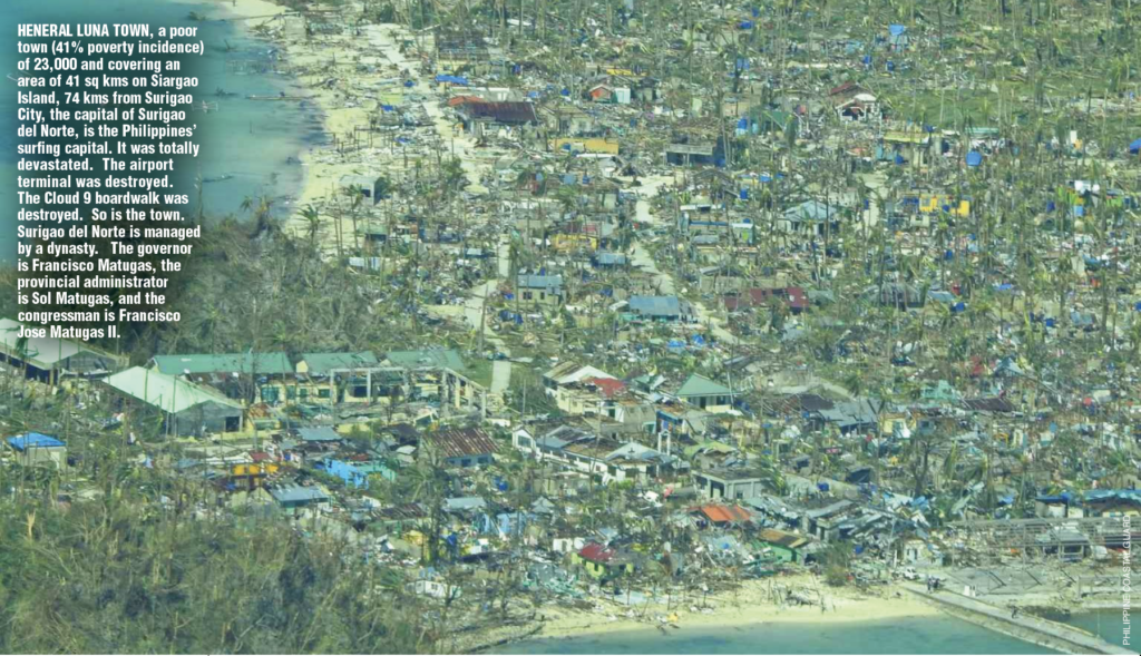
• 1:30 PM, 16 December 2021 in Siargao Island, Surigao del Norte
• 3:10 PM, 16 December 2021 in Cagdianao, Dinagat Islands
• 4:50 PM, 16 December 2021 in Liloan, Southern Leyte
• 5:40 PM, 16 December 2021 in Padre Burgos, Southern Leyte
• 6:30 PM, 16 December 2021 in Pres Carlos Garcia, Bohol
• 7:30 PM, 16 December 2021 in Bien Unido, Bohol
• 10:00 PM, 16 December 2021 in Carcar, Cebu
• 12:00 AM, 17 December 2021 in La Libertad, Negros Oriental
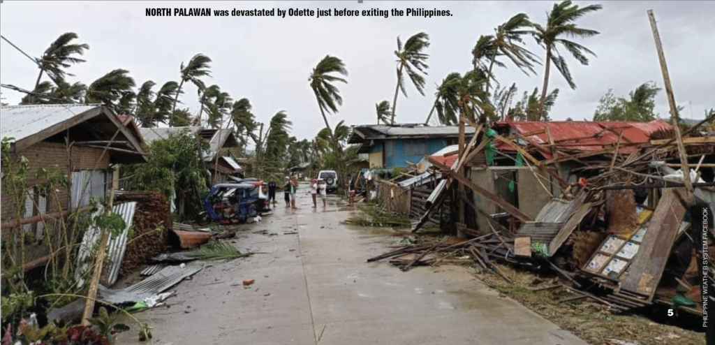
• 5:00 PM: 17 December 2021 in Roxas, Palawan.
Dec. 14, 2021
At 11:00 PM, Severe Tropical Storm “RAI” entered the PAR and was named “ODETTE”. It has a maximum sustained winds of 100 km/h near the center, gustiness of up to 125 km/h, and central pressure of 985 hPa, moving West Northwestward at 15 km/h.
Tropical Cyclone Warning Signal (TCWS) No. 1 was issued over the southeastern portion of Eastern Samar; Dinagat Islands, the eastern portion of Surigao del Norte including Siargao and Bucas Grande Islands, and the northern portion of Surigao del Sur.
Dec. 15, 2021
At 5:00 AM, “ODETTE” slightly intensifies and is nearing Typhoon category in strength. It has a maximum sustained winds of 110 km/h near the center, gustiness of up to 135 km/h, and central pressure of 980 hPa, moving West Northwestward at 25 km/h.
TCWS No. 1 was raised over Northern Samar, Eastern Samar, Samar, Biliran, Leyte, Southern Leyte, Bohol, and the northern and central portions of Cebu including Bantayan and Camotes Islands, Dinagat Islands, Surigao del Norte, Surigao del Sur, Agusan del Norte, Agusan del Sur, Camiguin, and the eastern portion of Misamis Oriental.
At 8:00 AM, “ODETTE” intensifies into a typhoon as it moves westward over the Philippine Sea east of Mindanao. It has a maximum sustained winds of 120 km/h near the center, gustiness of up to 150 km/h, and central pressure of 975 hPa.
TCWS No. 2 was issued over the eastern portion of Surigao del Norte and Surigao del Sur.
TCWS No. 1 was issuedover Sorsogon, Masbate including Ticao Island, the southern portion of Romblon, Eastern Samar, Northern Samar, Samar, Leyte, Biliran, Southern Leyte, Bohol, Cebu, Negros Oriental, Negros Occidental, Siquijor, Iloilo, Capiz, Aklan, Antique, Guimaras, Agusan del Sur, Agusan del Norte, the rest of Surigao del Norte, Dinagat Islands, the northern portion of Bukidnon, Misamis Oriental, Camiguin, the northern portion of Misamis Occidental, and the northern portion of Zamboanga del Norte, Agusan del Sur, Agusan del Norte, the rest of Surigao del Norte, Dinagat Islands, the northern portion of Bukidnon, Misamis Oriental, Camiguin, the northern portion of Misamis Occidental, and the northern portion of Zamboanga del Norte.
At 4:00 PM, TY “ODETTE” further intensified while moving westward over the Philippine Sea.
As of 7:00 PM, the center of TY “ODETTE” was estimated based on all available data at 535 km East of Surigao City, Surigao del Norte or 445 km East of Hinatuan, Surigao del Sur.
As of 11:00PM, TY “ODETTE” was estimated at 470 km East of Surigao City, Surigao del Norte. TCWS No. 3 was issued over Dinagat Islands, Surigao del Norte, the northern portion of Agusan del Norte, and the northern portion of Surigao del Sur.
TCWS No. 2 was issued over the southeastern portion of Masbate, the central and southern portions of Eastern Samar, the central and southern portions of Samar, Biliran, Leyte, Southern Leyte, Cebu, Bohol, Negros Oriental, Siquijor, Negros Occidental, Guimaras, and the eastern portion of Iloilo, the rest of Surigao del Sur, the rest of Agusan del Norte, Agusan del Sur, the northern portion of Bukidnon, the eastern and central portions of Misamis Oriental, and Camiguin
TCWS No. 1 was issued over Catanduanes, Camarines Sur, Albay, Sorsogon, the rest of Masbate including Ticao and Burias Islands, Marinduque, Romblon, the southern portion of Quezon, the southern portion of Batangas, Oriental Mindoro, Occidental Mindoro, and the northern and central portions of Palawan, including Calamian, Cagayancillo and Cuyo Islands, Northern Samar, the rest of Eastern Samar, the rest of Samar, Aklan, Antique, Capiz, and the rest of Iloilo, the northern portion of Davao Oriental, the northern portion of Davao de Oro, the northern portion of Davao del Norte, the rest of Misamis Oriental, Misamis Occidental, the central portion of Bukidnon, the northern portion of Lanao del Norte, the northern portion of Lanao del Sur, the northern portion of Zamboanga del Norte, and the northern portion of Zamboanga del Sur.
The Largest Weekly News and Business Magazine
Dec. 16, 2021
At 2:00 AM, TY “ODETTE” maintained its strength as it approached the waters off to the east of CARAGA region.
At 8:00 AM, “ODETTE” rapidly intensified as it continued to approach the vicinity of Dinagat Islands and Siargao-Bucas Grande Islands. It has maximum sustained winds of 165 km/h near the center, gustiness of up to 205 km/h, and central pressure of 950 hPa.
At 11:00 AM, TY “ODETTE” intensified further as it endangered the Bucas Grande-Siargao Islands and Dinagat Islands.
TCWS No. 4 was issued over Southern Leyte, and the eastern portion Bohol, Dinagat Islands, Surigao del Norte including Siargao and Bucas Grande Islands.
TCWS No. 3 was issued the southern portion of Leyte, the southern and central portions of Cebu, the rest of Bohol, Negros Oriental, Siquijor, the southern and central portions of Negros Occidental, and Guimaras, northern portion of Agusan del Norte, and the northern portion of Surigao del Sur.
TCWS No. 2 was issued over the southern portion Albay, Sorsogon, Masbate including Ticao and Burias Islands, Romblon, the central and southern portions of Oriental Mindoro, the central and southern portions of Occidental Mindoro Palawan, Northern Samar, Eastern Samar, Samar, Biliran, the rest of Leyte, the rest of Cebu, the rest of Negros Occidental, Iloilo, Capiz, Aklan, and Antique, the rest of Surigao del Sur, Agusan del Sur, the rest of Agusan del Norte, the extreme northern portion of Zamboanga del Norte, the extreme northern portion of Zamboanga del Sur, Misamis Occidental, the northern portion of Lanao del Norte, Misamis Oriental, Camiguin, the northern portion of Bukidnon and the northern portion of Lanao del Sur.
TCWS No. 1 was issued over Catanduanes, Camarines Norte, Camarines Sur, the rest of Albay, Marinduque, the southern portion of Quezon, Batangas, the rest of Oriental Mindoro, the rest of Occidental Mindoro, the rest of mainland Palawan including Balabac and Kalayaan Islands, The northern portion of Davao Oriental, the northern portion of Davao de Oro, the northern portion of Davao del Norte, the rest of Bukidnon, the rest of Lanao del Norte, the rest of Lanao del Sur, the rest of northern portion of Zamboanga del Norte, the rest of northern portion of Zamboanga del Sur, and the northern portion of Zamboanga Sibugay.
At 8:00 PM, TY “ODETTE” slightly weakened while traversing the northern portion of Bohol. At 10:00 PM, “ODETTE” further weakened and made landfall in the vicinity of Carcar, Cebu. It has maximum sustained winds of 175 km/h near the center, gustiness of up to 240 km/h, and central pressure of 935 hPa.
Dec. 17, 2021
At 4:00 AM, the center of the eye of TY “ODETTE” was located at 75 km Southwest of Iloilo City, with maximum sustained winds of 155 km/h near the center, gustiness of up to 235 km/h, and central pressure of 950 hPa.
TCWS No. 3 was raised over the northern portion of Palawan including Cagayancillo and Cuyo Islands, Guimaras, the southern portion of Iloilo, the southern portion of Antique, the central and southern portions of Negros Occidental, and the central portion of Negros Oriental.
TCWS No. 2 was raised over the southern portion of Oriental Mindoro, the southern portion of Occidental Mindoro, Romblon, the southern portion of Masbate, and the central portion of Palawan including Kalayaan and Calamian Islands, Aklan, Capiz, the rest of Antique, the rest of Iloilo, the rest of Negros Oriental, the rest of Negros Occidental, Cebu, Siquijor, and the western portion of Bohol.
TCWS No. 1 was raised over Catanduanes, Camarines Norte, Camarines Sur, Albay, Sorsogon, the rest of Masbate including Ticao and Burias Islands, Marinduque, the southern portion of Quezon, the rest of Occidental Mindoro including Lubang Islands, the rest of Oriental Mindoro, the rest of Palawan, Batangas, Eastern Samar, Samar, Northern Samar, Biliran, Leyte, Southern Leyte, and the rest of Bohol, Dinagat Islands, Surigao del Norte, Agusan del Norte, Misamis Oriental, Camiguin, Lanao del Norte, Misamis Occidental, the northern portion of Zamboanga del Norte, and the northern portion of Zamboanga del Sur.
At 7:00 AM, the center of the eye of Typhoon “ODETTE” was located at 155 km West Southwest of Iloilo City or 90 km South Southeast of Cuyo, Palawan.
TCWS No. 3 was hoisted in the northern portion of Palawan including Cagayancillo and Cuyo Islands; and Visayas in Guimaras, the southern portion of Iloilo, and the southern portion of Antique.
TCWS No. 2 was raised over Oriental Mindoro, the southern portion of Occidental Mindoro, the western portion of Romblon, and the central portion of Palawan including Kalayaan and Calamian Islands; and Visayas in Aklan, Capiz, the rest of Iloilo, the rest of Antique, Guimaras, Negros Oriental, Negros Occidental, and the southern portion of Cebu.
TCWS No. 1 was hoisted in the western portion of Camarines Sur, Albay, Sorsogon, Masbate including Ticao and Burias Islands, Marinduque, the southern portion of Quezon, the rest of Occidental Mindoro including Lubang Islands, the rest of Oriental Mindoro, the rest of Palawan, the rest of Romblon, and Batangas; Visayas in the western portion of Northern Samar, the western portion of Samar, Bohol, Biliran, Leyte, the western portion of Southern Leyte, the rest of Cebu including Bantayan and Camotes Islands, and Siquijor; and Mindanao in the northern portion of Zamboanga del Norte, and the northern portion of Misamis Occidental.
As of 10:00 AM,the center of the eye of Typhoon “ODETTE” was located at 90 km South Southwest of Cuyo, Palawan with maximum sustained winds of 155 km/h near the center, gustiness of up to 215 km/h, and central pressure of 955 hPa.
TCWS No. 3 was raised in Luzon particularly in the northern portion of Palawan including Cagayancillo and Cuyo Islands; Visayas in the southern portion of Iloilo, and the southern portion of Antique.
TCWS No. 2 was raised in Luzon particularly in the southern portion of Oriental Mindoro, the southern portion of Occidental Mindoro, the western portion of Romblon, and the central portion of Palawan including Kalayaan, and Calamian Islands; Visayas in Aklan, Capiz, the rest of Iloilo, the rest of Antique, Guimaras, the northern and central portions of Negros Oriental, and Negros Occidental.
TCWS No. 1 was raised in Luzon particularly in Masbate including Ticao and Burias Islands, Marinduque, the southern portion of Quezon, the rest of Occidental Mindoro including Lubang Islands, the rest of Oriental Mindoro, the rest of Palawan, the rest of Romblon, and Batangas; Visayas in Cebu including Bantayan and Camotes Islands, Bohol, Biliran, the western portion of Leyte, the western portion of Southern Leyte, and Siquijor; and Mindanao in the northern portion of Zamboanga del Norte, and the northern portion of Misamis Occidental.
Tropical Cyclone Wind Signals hoisted in areas that are no longer listed herein were lifted.
At 1:00 PM, the center of the eye of Typhoon “ODETTE” was located 130 km Southwest of Cuyo, Palawan or 155 km East Northeast of Puerto Princesa City, Palawan.
TCWS No. 3 was raised in the northern portion of Palawan including Cagayancillo and Cuyo Islands.
TCWS No. 2 was raised over southern portion of Oriental Mindoro, the southern portion of Occidental Mindoro, and the central portion of Palawan including Kalayaan and Calamian; Visayas – the southwestern portion of Negros Occidental, Antique, the northwestern and western portions of Aklan, the southwestern portion of Capiz, the central and southern portions of Iloilo, and Guimaras
TCWS No. 1 was also raised in Batangas, the southeastern portion of Quezon, Marinduque, Masbate, and Romblon; Visayas in the western portion of Bohol, Siquijor, Cebu including Bantayan Islands, the rest of Negros Occidental, Negros Oriental, the rest of Capiz, the rest of Iloilo, and the rest of Aklan; and Mindanao – the northern portion of Zamboanga del Norte, and the northern portion of Misamis Occidental.
Odette goes to Palawan
At 4:00 PM, the center of the eye of Typhoon “ODETTE” was located based on all available data over the coastal waters of San Vicente, Palawan with Maximum sustained winds of 150 km/h near the center, gustiness of up to 205 km/h, and central pressure of 960 hPa.
At 5:00 PM, “ODETTE” weakened slightly and made landfall over Roxas, Palawan.
TCWS No. 3 was raised in the northern portion of Palawan, No. 2 in the central portion of Palawan including Kalayaan, Calamian, Cuyo, and Cagayancillo Islands, and No. 1 in Luzon particularly in Oriental Mindoro, Occidental Mindoro, and the western portion of Romblon, and the rest of Palawan; and Visayas in Aklan, Capiz, Iloilo, Antique, the western portion of Negros Occidental, and Guimaras.
At 7:00 PM, the center of the eye of Typhoon “ODETTE” was located over the coastal waters of San Vicente, Palawan or 85 km North of Puerto Princesa City moving Westward northwestward at 30 km/h with maximum sustained winds of 150 km/h near the center, gustiness of up to 205 km/h, and central pressure of 960 hPa.
TCWS No. 3 was raised in the northern portion of Palawan including Kalayaan Islands, No. 2 in the central portion of Palawan (Narra, Sofronio Española, Quezon, Aborlan, Rizal, Brooke’s Point) including Calamian, Cuyo, and Cagayancillo Islands, and No. 1 over the rest of Palawan. As of 10:00 PM, the center of the eye of Typhoon “ODETTE” was located 105 km Northwest of Puerto Princesa City, Palawan. At 11:00 PM, Typhoon “ODETTE” maintains its strength while moving towards the Kalayaan Islands.
TCWS No. 3 was raised in the northern portion of Palawan including Kalayaan Islands, No. 2 in the central portion of Palawan including Calamian Islands, and No. 1 to the rest of Palawan including Cuyo and Cagayancillo Islands.
READ FULL ARTICLE HERE: